NTv2Poly
NTv2Poly spatial software inserts Polygonal Validity Scopes in NTv2 binary files
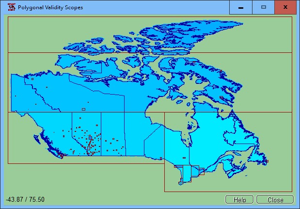
The spatial software NTv2Poly replaces the rectangular activity scope contained in NTv2 files with a Polygonal Validity Scope, which is realized with an outline file in classic Shape Format. Invalid calculations outside the Polygonal Validity Scope thus can be excluded or acknowledged by a warning. Download the trial version from http://www.killetsoft.de/zip/ntv2poly.zip. Read the Worksheet at http://www.killetsoft.de/t_1808_e.htm. Using NTv2 grid files it is possible to transform points from one coordinate reference system to another with very high accuracy. An NTv2 file contains one or more quasi-rectangular coordinate grids which are defined in the NTv2 headers. Instead of a rectangular area only an embedded polygonal area should and must be covered, for example, a state territory within the country borders. The program NTv2Poly realizes Polygonal Validity Scopes in NTv2 files. Using so prepared NTv2 files, coordinates outside the validity scope can be excluded from calculations or they can be acknowledged by a warning. This works with coordinate transformations using the geospatial software TRANSDAT and GeoDLL by KilletSoft and with many GIS programs which support Polygonal Validity Scopes. The Polygonal Validity Scope is realized with a shape file, which contains the outlines of the scope as polygons. The file format Shape is developed by ESRI as a format for geographical objects. For example, in the shape file the border outlines of a country may be stored, which represent the polygonal scope for the NTv2 file used in that country. Using the program NTv2Poly the polygons of the shape file and the quasi rectangular surface of the NTv2 file are superimposed one on the other and processed in an ingenious manner. The program has a user-selectable multi language interface and comes with extensive online help. The program can be run on most common networks and it is possible to use Terminal Services on WINDOWS Servers.
Changes: First release. New worksheet at http://www.killetsoft.de/t_1808_e.htm in English. New worksheet at http://www.killetsoft.de/t_1808_d.htm in German.
Minimum requirements: Pentium, 30 MB HD
Operating system: Win2000,WinXP,Win7 x32,Win7 x64,Windows 8,Windows 10,WinServer,WinOther,Windows2000,Windows2003,Windows Server 2012,Windows Tablet PC Edition 2005,Windows Media Center Edition 2005,WinVista,Windows Vista Starter,Windows Vista Home Basic,Windows Vista Home Premium,Windows Vista Business,Windows Vista Enterprise,Windows Vista Ultimate,WinVista x64,Windows Vista Home Basic x64,Windows Vista Home Premium x64,Windows Vista Business x64,Windows Vista Enterprise x64,Windows Vista Ultimate x64
Program URL: http://www.killetsoft.de/p_ntpa_e.htm
NTv2Poly screenshot
Press release: NTv2Poly is a new software for inserting area boundaries as Polygonal Validity Scopes in NTv2 files.
With the geospatial software NTv2Poly by KilletSoft the rectangular activity scopes of NTv2 files can be replaced by Polygonal Validity Scopes which are defined as area boundaries in classic shape files.
Special permissions
Hereby C. Killet Softwareentwickung GbR permits to distribute their software NTv2Poly exclusive as shareware version on data media and in the online media up to revocation. We guarantee to possess all rights on the software. We exempt the legal distributor of our software from requirements third. With the revocation of the permission all projects in work with our software may be led to the end.
EULA
A single program license entitles the license holder to use the program on a single computer in the license holder's place of work. A network program license entitles the license holder to use the program on a single network of the license holder's principal branch/subsidiary office. A general program license entitles the license holder to use the program on all computers and networks of the license holder's branch/subsidiary office.