ORTWIN
ORTWIN is a program for the inquiry of the localities in Germany.
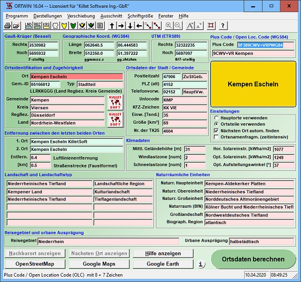
ORTWIN is a program for the state-wide inquiry of the localities, postal codes and telephone selections in Germany. It finds postal zip codes, telephone pre selections, coordinates and ground level elevations. The program determines municipal codes, local center points, car license codes, topographic maps, Unlocodes and much more. It arranges localities hierarchically into the structures federal state, administrative district, rural district, town, municipality, local quarter and domicile. The program performs perimeter searches and distance calculations. It finds landscapes on different levels, natural units and snow- and wind load zones of all localities. In a radius around a place or around a postal code area covered localities and postal areas can be clearly represented by a comfortable perimeter search. They can also be arranged in a list, stored as a file and printed. For the local inquiries and perimeter searches a data base with more than 120.000 geo coded localities is available. The program represents local data, determined by local inquiries and perimeter searches, in graphic overviews and data lists. The program supports conversions between different coordinate systems and the distance calculation between the places. It calculates with Gauss Krueger coordinates referring to the Potsdam Datum (Bessel ellipsoid, Rauenberg) and with Geographic Coordinates on the geodetic datum WGS84. It also works with UTM coordinates, which refer to the datum ETRS89 (GRS80, geocentric). The functionality of the program is described in a detailed electronic manual. The program can be run on most common networks and it is possible to use Terminal Services on WINDOWS Servers. The client installations are done automatically.
Changes: Digital signature for secure installation of the program. Determining wind load zones and snow load zones. ORTWIN wins Innovation Award 2016. View of localities in OpenStreetMap, Google Maps, Google Earth. WINDOWS©10 certification after 32Bit / 64Bit test. Travel areas and solar irradiation added.
Minimum requirements: Pentium, 50 MB HD
Operating system: WinXP,WinVista,WinVista x64,Win7 x32,Win7 x64,Win2000,WinOther,Windows2000,Windows2003,WinServer,Windows Vista Ultimate,Windows Vista Ultimate x64,WinMobile,Windows CE,WinME,WinNT 3.x,WinNT 4.x,Windows Tablet PC Edition 2005,Windows Media Center Edition 2005,Windows Vista Starter,Windows Vista Home Basic,Windows Vista Home Premium,Windows Vista Business,Windows Vista Enterprise,Windows Vista Home Basic x64,Windows Vista Home Premium x64,Windows Vista Business x64,Windows Vista Enterprise x64,Windows Mobile 2003,Windows Mobile 2005,Windows 10,Windows 8,Windows Server 2012
Program URL: http://www.killetsoft.de/p_orwa_d.htm
ORTWIN screenshot
Killet Software Ing.-GbR, Geo-Software-Entwickler mit Sitz am Niederrhein, stellt mit dem Produkt "Geodaten Deutschland" Fachdaten mit Raumbezug auf administrativer und postalischer Ebene zur Verfügung.
Special permissions
Hereby C. Killet Softwareentwickung GbR permits to distribute their software exclusive as shareware version on data media and in the online media up to revocation. We guarantee to possess all rights on the software. We exempt the legal distributor of our software from requirements third. With the revocation of the permission all projects in work with our software may be led to the end.
EULA
A single program license entitles the license holder to use the program on a single computer in the license holders place of work. A network program license entitles the license holder to use the program on a single network of the license holders principal branch/subsidiary office. A general program license entitles the license holder to use the program on all computers and networks of the license holders branch/subsidiary office.