RTOPO Hydrology
XYZ File editor, triangulation, isolines, hydrology, sections.
Simple, powerful and inexpensive CAD software for surveying. You can do triangulation, isolines, color-filled contour maps, sections, intersections, volume and much more. You can process hundreds of thousands of points or triangles, even on less powerful PCs. Through its own CAD system (called RCAD), specialized for 3D and for a large number of entities, you can: -load and draw a file of points having the format: Number X Y Z Code; the drawing is made by POINT,3DPOLY,SPLINE or BLOCK entities, according to a modifiable library of codes -edit interactively the XYZ files of points; you can modify the coordinates, the code and the position (in 3DPOLY or SPLINE) -triangulate the points on a convex hull or between an external contour and possibly more interior contours -do isolines (contour lines) and color-filled contour map -do cross sections and longitudinal profile -do the projection of several PLine entities over a triangulation -do simulation of rainwater runoff -do the conversion of a triangulation to a regular grid of points -do the conversion of the existing isolines resulting from maps in points and then in a triangulation -represent the geological_stratification resulting from drilling -calculate 3D area, center of gravity and the volume between 2 triangulations or between a triangulation and a plan -intersect and divide two triangulations or a triangulation by a horizontal plan -interpolate a set of 3DFACE entities, using quartic triangular patches (G1 continuity) -transform a drawing containing entities as PLine, Line, Block and Text, in XYZ points file -represent 4D points cloud, -import and export LandXML files type. RCAD CAD system, distributed together with RTOPO, provides OpenGL real-time orbit, pan,zoom, shading, lighting and motion path animation. RCAD is similar with other popular CAD systems and can load and save DXF files. It has entries in the command text area, graphics area, menus and toolbars and can run scripts.
Changes: It can simulate rainwater runoff.
Minimum requirements: Graphic card with OpenGL hardware acceleration and 32-bit color depth
Operating system: Win2000,WinXP,Win7 x32,Win7 x64,Windows 8,Windows 10,WinServer,WinOther,Windows2000,Windows2003,Windows Server 2000,Windows Server 2003,Windows Server 2008,Windows Server 2008r2,Windows Server 2012,Windows Tablet PC Edition 2005,Windows Media Center Edition 2005,WinVista,Windows Vista Starter,Windows Vista Home Basic,Windows Vista Home Premium,Windows Vista Business,Windows Vista Enterprise,Windows Vista Ultimate,WinVista x64,Windows Vista Home Basic x64,Windows Vista Home Premium x64,Windows Vista Business x64,Windows Vista Enterprise x64,Windows Vista Ultimate x64
Program URL: http://rcad.eu/rtopo/
Video: http://rcad.eu/rtopo/rtopo-animated-demo/
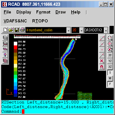
Linikedin Twitter FacebookRTOPO Hydrology screenshot
Special permissions
This SOFTWARE may be distributed freely on online services, bulletin boards, or other electronic media as long as the files are distributed only "AS IS" in this installation package. This SOFTWARE may not be distributed on CD-ROM, disk, or other physical media for a fee without the permission of the Author.
EULA
RTOPO Copyright (c) 2006 RCAD SOFTWARE SRL e-mail: office@rcad.eu , rcad.software@gmail.com site: http://www.rcad.eu All copyrights of "RTOPO " software application are exclusively owned by the author - RCAD SOFTWARE SRL. LICENSE AGREEMENT RTOPO is shareware software application with 30 days trial period.