Soil Profile Visualization Software VisLog
Make a 3D model from your borehole logs and field tests (CPT, DCPT, SPT, etc)
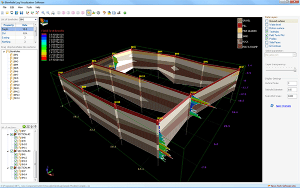
Using VisLog, the user will be able to enter borehole information make a 3-dimensional interactive view of the subsurface layers. Input data can be entered manually or imported directly from gINT. The 3D model can then be exported to PDF, image formats and movie format which are easily viewable by the clients and can be attached to geotechnical reports. With intelligent engine of VisLog, generating soil profiles between boreholes is as easy as 1-2-3. VisLog can even be used for ground improvement projects to visualize the results. Visit our website for more information http://novotechsoftware.com/geotechnical-software/3d-soil-profile-visualization/
Changes: Export to movie format
Minimum requirements: .Net Framework 4.5.2
Operating system: Win2000,WinXP,Win7 x32,Win7 x64,Windows 8,Windows 10,WinServer,WinOther,Windows2000,Windows2003,Windows Server 2000,Windows Server 2003,Windows Server 2008,Windows Server 2008r2,Windows Server 2012,Windows Tablet PC Edition 2005,Windows Media Center Edition 2005,WinVista,Windows Vista Starter,Windows Vista Home Basic,Windows Vista Home Premium,Windows Vista Business,Windows Vista Enterprise,Windows Vista Ultimate,WinVista x64,Windows Vista Home Basic x64,Windows Vista Home Premium x64,Windows Vista Business x64,Windows Vista Enterprise x64,Windows Vista Ultimate x64
Program URL: https://novotechsoftware.com/geotechnical-software/3d-soil-profile-visualization/
Video: https://www.youtube.com/watch?v=Oz4fu9tuaEE&list=UUSpG407NLeE5DP9mNaZ_w2g
Linikedin Twitter FacebookSoil Profile Visualization Software VisLog screenshot
Special permissions
For distribution agreement refer to http://www.novotechsoftware.com
EULA
https://novotechsoftware.com/eula/