TOPOWIN
TOPOWIN is a state-wide register of the German topographic cartographies.
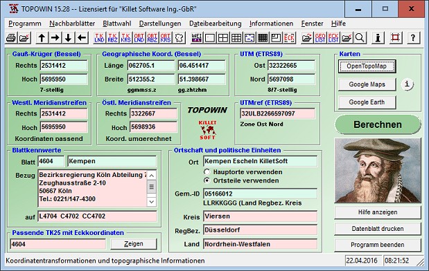
TOPOWIN is a state-wide register of the German Topographic Cartographies, the German Basic Cartography and of localities with geo references in different coordinate systems. It is also a topographic information system. In the division of planning and execution of economical and scientific projects frequently topographic documents are used. The program TOPOWIN makes information available of the official topographic cartographies and the German Basic Cartography from the entire national territory in suitable graphic views. It accomplishes different coordinate transformations and inquiries. The program was developed under co-operation of the land surveying authorities of many German Federal States. For the first time in the previous version TOPO (for DOS) and later in TOPOWIN state-wide topographic information were arranged for the data technical evaluation. The program is for consulting engineers, planning authorities and users of topographic maps a useful and versatile tool. The topographical maps of different standards, required for a project, can be determined by the entering of known parameters or by the direct selection from overview graphics and from sorted lists. By the investigation of topographical records on the basis of known places, a data base with more then 105.000 places and residential districts is available. The program TOPOWIN calculates with Gauss Krueger coordinates and Geographic Coordinates refering to the Potsdam Datum (Bessel ellipsoid with central point Rauenberg). It also works with UTM coordinates and UTMRef coordinates in the NATO standard, which refer to the datum ETRS89 (GRS80 / WGS84, geocentric).
Changes: Digital signature for secure installation of the program. All map views supplemented with UTM edge coordinates. Program completely redesigned and functional supplemented. View of maps in OpenTopoMap, Google Maps, Google Earth. WINDOWS©10 certification after 32Bit / 64Bit intensive test.
Minimum requirements: Pentium, 50 MB HD
Operating system: WinXP,WinVista,WinVista x64,Win7 x32,Win7 x64,Win2000,WinOther,Windows2000,Windows2003,WinServer,Windows Vista Ultimate,Windows Vista Ultimate x64,WinMobile,Windows CE,WinME,WinNT 3.x,WinNT 4.x,Windows Tablet PC Edition 2005,Windows Media Center Edition 2005,Windows Vista Starter,Windows Vista Home Basic,Windows Vista Home Premium,Windows Vista Business,Windows Vista Enterprise,Windows Vista Home Basic x64,Windows Vista Home Premium x64,Windows Vista Business x64,Windows Vista Enterprise x64,Windows Mobile 2003,Windows Mobile 2005,Windows 10,Windows 8,Windows Server 2012
Program URL: http://www.killetsoft.de/p_tpwa_e.htm
TOPOWIN screenshot
Mit Erfolg vertreibt KilletSoft seit vielen Jahren geodätische Funktionen zum Einbinden in eigene Computerprogramme.
Special permissions
Hereby C. Killet Softwareentwickung GbR permits to distribute their software exclusive as shareware version on data media and in the online media up to revocation. We guarantee to possess all rights on the software. We exempt the legal distributor of our software from requirements third. With the revocation of the permission all projects in work with our software may be led to the end.
EULA
A single program license entitles the license holder to use the program on a single computer in the license holders place of work. A network program license entitles the license holder to use the program on a single network of the license holders principal branch/subsidiary office. A general program license entitles the license holder to use the program on all computers and networks of the license holders branch/subsidiary office.